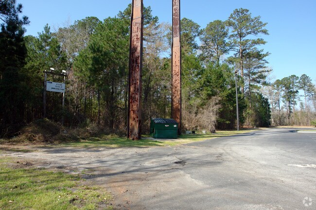
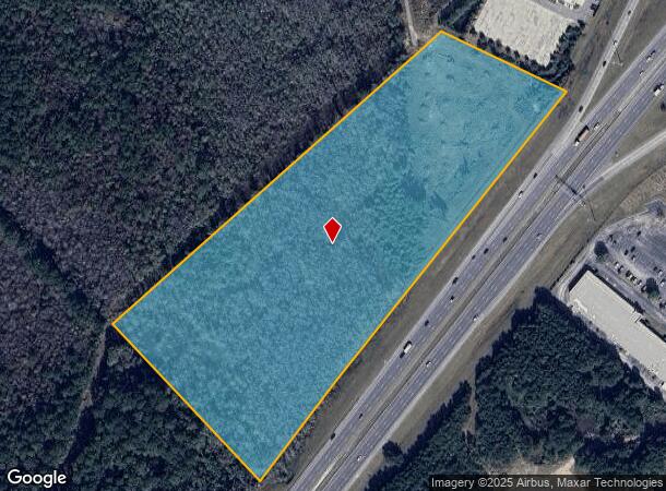
Property Record
17 Fort Argyle Rd, Savannah, GA 31419

NEARBY LISTINGS FOR SALE OR LEASE
Property Detail
17 Fort Argyle Rd
Savannah, GA
I95/ Abrcrn Ext
2103301002
PORTION OF A TCT S W INTERSECTIO N OF I 95 + FT ARGYLE RD KNOWN
Vacantlandnec
Chatham
AE
Georgia
13051C0118H
16.19 AC
2023
Outlying Chatham County
2025
Savannah
010806
DEMOGRAPHICS near 17 Fort Argyle Rd
1 Mile
3 Mile
5 Mile
2024 Total Population
2,922
10,452
46,038
2029 Population
3,005
10,911
48,805
Pop Growth 2024-2029
+ 2.84%
+ 4.39%
+ 6.01%
Average Age
35
35
37
2024 Total Households
1,150
3,973
17,628
HH Growth 2024-2029
+ 3.04%
+ 4.40%
+ 5.81%
Median Household Inc
$67,214
$56,202
$73,981
Avg Household Size
2.50
2.60
2.60
2024 Avg HH Vehicles
2.00
2.00
2.00
Median Home Value
$209,375
$211,908
$226,221
Median Year Built
2007
2005
2002
Nearby Places
Map Layers
Map Styles
 Street
 Aerial
- Restaurants
- Banks
- Shops
- Fitness
- Groceries
PUBLIC TRANSPORTATION
AIRPORT
Savannah/Hilton Head International
DRIVE
WALK
Distance
Savannah/Hilton Head International
30 min
20.3 mi
Freight Ports
Georgia Ports - Savannah
DRIVE
WALK
Distance
Georgia Ports - Savannah
36 min
24.4 mi
SALE & LEASE HISTORY
LISTING DATE
SALE/LEASE

Sep 24, 2016
For Sale
Aug 28, 2017
For Sale
Nearby Properties
Address
Land Use
TOTAL SIZE
Lot Size
Zoning
Address
Land Use
TOTAL SIZE
Lot Size
Zoning
1,004,400 SF
119.73 AC
Address
Land Use
TOTAL SIZE
Lot Size
Zoning
6,580 SF
42.03 AC
PUDM-12
Address
Land Use
TOTAL SIZE
Lot Size
Zoning
8,544 SF
22.40 AC
PBC
Address
Land Use
TOTAL SIZE
Lot Size
Zoning
8,784 SF
29.43 AC
PUDM10
Address
Land Use
TOTAL SIZE
Lot Size
Zoning
8,208 SF
48.30 AC
PUDC
Address
Land Use
TOTAL SIZE
Lot Size
Zoning
23,262 SF
59.37 AC
RM-25
Address
Land Use
TOTAL SIZE
Lot Size
Zoning
6,278 SF
24.47 AC
RA
Address
Land Use
TOTAL SIZE
Lot Size
Zoning
12,432 SF
14.51 AC
PUDM
Address
Land Use
TOTAL SIZE
Lot Size
Zoning
94,808 SF
43.60 AC
RA
Address
Land Use
TOTAL SIZE
Lot Size
Zoning
8,544 SF
13.03 AC
PBC
Address
Land Use
TOTAL SIZE
Lot Size
Zoning
112.37 AC
RA
Address
Land Use
TOTAL SIZE
Lot Size
Zoning
221,171 SF
28.22 AC
PBC
Address
Land Use
TOTAL SIZE
Lot Size
Zoning
64,800 SF
2.83 AC
PUDC
Address
Land Use
TOTAL SIZE
Lot Size
Zoning
9,170 SF
10 AC
PUDM6
Address
Land Use
TOTAL SIZE
Lot Size
Zoning
47,913 SF
2.39 AC
PBC
Address
Land Use
TOTAL SIZE
Lot Size
Zoning
100,360 SF
23.81 AC
BG
Address
Land Use
TOTAL SIZE
Lot Size
Zoning
8.58 AC
Address
Land Use
TOTAL SIZE
Lot Size
Zoning
40,560 SF
2.46 AC
Address
Land Use
TOTAL SIZE
Lot Size
Zoning
8,488 SF
47.68 AC
RA
Address
Land Use
TOTAL SIZE
Lot Size
Zoning
9,720 SF
2.32 AC
PUDR
Address
Land Use
TOTAL SIZE
Lot Size
Zoning
56,406 SF
3.79 AC
PBC
Address
Land Use
TOTAL SIZE
Lot Size
Zoning
67,233 SF
15 AC
PBC
Address
Land Use
TOTAL SIZE
Lot Size
Zoning
48,600 SF
5.53 AC
PBC
Address
Land Use
TOTAL SIZE
Lot Size
Zoning
13,200 SF
2.62 AC
PBC
Address
Land Use
TOTAL SIZE
Lot Size
Zoning
56,160 SF
2.50 AC
PBC
Address
Land Use
TOTAL SIZE
Lot Size
Zoning
71,021 SF
4.65 AC
PBC
Address
Land Use
TOTAL SIZE
Lot Size
Zoning
4,000 SF
102.32 AC
Address
Land Use
TOTAL SIZE
Lot Size
Zoning
45.56 AC
PBC
Address
Land Use
TOTAL SIZE
Lot Size
Zoning
83.92 AC
PBC
Address
Land Use
TOTAL SIZE
Lot Size
Zoning
1,800 SF
51.20 AC
RA
The World's #1 Commercial Real Estate Marketplace
Connect with us
© 2025 CoStar Group
The information above has been obtained from sources believed reliable. While we do not doubt its accuracy we have not verified it and make no guarantee, warranty or representation about it. It is your responsibility to independently confirm its accuracy and completeness. Any projections, opinions, assumptions, or estimates used are for example only and do not represent the current or future performance of the property. The value of this transaction to you depends on tax and other factors which should be evaluated by your tax, financial, and legal advisors. You and your advisors should conduct a careful, independent investigation of the property to determine to your satisfaction the suitability of the property for your needs.